

Book your Water Motorbike Malta adventure! Jet Ski rentals & safaris with online discounts. Ride across Malta, Gozo & Comino’s crystal waters.
Discover Our Exciting Blogs on Water Adventures and More
Ghar Hasan
Discover Ghar Hasan in Malta—where history, legend, and breathtaking cliffs tell a timeless story of love, tragedy, and resilience.
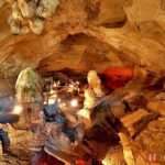
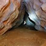
Ghar Dalam
Ghar Dalam: Exploring Malta’s Prehistoric Treasure Hidden in the quiet town of Birzebbuga in southern Malta lies one of the island’s most fascinating archaeological and natural wonders: Ghar Dalam. This prehistoric cave, whose name translates to “Cave of Darkness” in Maltese, is far more than just a cavern. It is a time capsule, preserving within its layers the story of Malta’s earliest human settlers and the animals that once roamed the island thousands of years ago. For travelers seeking a deeper understanding of Malta’s ancient past beyond its beautiful beaches and lively towns, Ghar Dalam is a destination that blends history, geology, and archaeology in one remarkable site. A Journey Back in Time Stepping into Ghar Dalam feels like traveling back through millennia. The cave stretches for about 145 meters, although visitors can explore roughly the first 50 meters. What makes it extraordinary are the layers of sediment within the cave walls. These layers hold fossils, bones, and artifacts that together create a timeline of Malta’s distant past, dating back over 500,000 years. Excavations in the 19th and 20th centuries revealed a treasure trove of prehistoric animal remains. Among the most notable are dwarf elephants, hippopotamuses, and giant swans. These species once lived on the Maltese Islands during the Ice Age, when Malta was connected to mainland Europe via land bridges. As sea levels rose, these animals became isolated, and many species eventually shrank in size due to limited resources—a fascinating example of island dwarfism. The bones and fossils found here are not just random discoveries; they are meticulously layered, with each stratum representing a different period in natural history. Walking along the cave, visitors can see the way archaeologists have carefully marked these layers, turning the walls into a textbook of Earth’s history. Malta’s First Inhabitants While Ghar Dalam is famous for its Ice Age animals, it is equally significant for its human history. Archaeologists discovered pottery shards and tools dating back to around 7,400 years ago, making this site the earliest evidence of human settlement on the Maltese Islands. These Neolithic settlers are believed to have arrived from Sicily, bringing with them rudimentary farming techniques, livestock, and a new way of life. They sought shelter in and around the cave, which provided a safe haven as they began to establish their communities. This marked the beginning of Malta’s long and rich prehistory, which would later give rise to the awe-inspiring megalithic temples scattered across the islands. The discovery of these artifacts at Ghar Dalam gives visitors a unique glimpse into the resilience and resourcefulness of Malta’s first inhabitants, who transformed a barren landscape into a thriving home. The Cave Museum Before entering the cave itself, visitors can explore the Ghar Dalam Museum, which offers an excellent introduction to the site. Opened in 1933, the museum houses a vast collection of fossils, bones, and artifacts unearthed from the cave. One of its most captivating displays is the skeleton of a dwarf elephant, a reminder of the extraordinary creatures that once walked on CONTINUE READING
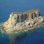
Filfla
Filfla: Malta’s Mysterious Islet of Legends and Nature ust 5 kilometers off the southern coast of Malta lies a tiny, rugged islet that has intrigued locals, historians, and nature lovers for centuries—Filfla. Despite its small size, only about 0.06 km², Filfla carries a big story. Steeped in myths, layered with history, and brimming with ecological importance, this uninhabited limestone rock remains one of the most mysterious parts of the Maltese archipelago. The Origins of Filfla Geologically, Filfla is part of the same limestone composition that forms much of the Maltese Islands. It is believed that the islet was once much larger, but centuries of erosion, earthquakes, and natural forces reduced it to its present size. Surrounding it are two smaller rocks—Filfoletta and another unnamed rock—making the site all the more dramatic against the deep blue Mediterranean backdrop. The name “Filfla” comes from the Arabic word for peppercorn, a nod to the island’s round, pebble-like shape. This etymology also points to Malta’s long history as a cultural crossroads between Europe, North Africa, and the Middle East. Legends and Folklore Filfla has inspired countless legends among the Maltese people. One popular folk tale says that the islet was thrown into the sea by a giant who was angered at the Maltese villagers. Another story claims that witches used to live on Filfla, holding midnight gatherings that frightened sailors passing by. Perhaps the most striking legend is that Filfla was once home to a chapel, which sank beneath the sea after a great storm—a symbolic tale often used in local storytelling to highlight divine power and human fragility. While there is no evidence of a chapel on Filfla itself, these myths have helped cement the islet’s reputation as a place of mystery and awe. A Military Past Though uninhabited, Filfla was not always left in peace. During the British colonial period, the Royal Navy used the islet for target practice. From the late 19th century up until 1971, Filfla was regularly bombarded as part of military training exercises. This left the islet scarred and littered with unexploded ordnance. In 1980, the Maltese government officially declared Filfla a nature reserve, banning all forms of human activity—including fishing within one nautical mile of the islet. The law was passed not only to protect the unique ecosystem but also to safeguard visitors from potential dangers caused by the old military shells. Filfla’s Unique Wildlife Today, Filfla is recognized for its ecological value. Despite its barren and inhospitable appearance, the islet is home to species that thrive only in this isolated environment. The most famous is the Filfla lizard (Podarcis filfolensis filfolensis), a subspecies found nowhere else on Earth. These small reptiles have adapted to the harsh, rocky terrain and are a symbol of Malta’s natural resilience. Filfla is also a vital seabird sanctuary. Large colonies of European storm petrels, yellow-legged gulls, and Cory’s shearwaters use its cliffs as breeding grounds. The surrounding waters are equally rich, supporting diverse marine life, making the area a hotspot for CONTINUE READING

Scenic Natural Spots & Outdoor Activities
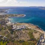
Scenic Natural Spots & Outdoor Activities in Malta and Gozo When you think of Malta and Gozo, your mind might instantly wander to historic cities, grand fortresses, and vibrant culture. Yet, these Mediterranean gems also boast breathtaking natural landscapes and endless outdoor activities for those seeking adventure and tranquility. From dramatic cliffs and hidden caves to pristine beaches and rustic countryside trails, the islands are perfect for nature enthusiasts who want to combine relaxation with exploration. Malta’s Natural Treasures & Scenic Natural Spots Dingli Cliffs – Rising dramatically above the sea, the Dingli Cliffs are one of the highest points in Malta, offering panoramic views that stretch to the horizon. This natural wonder is ideal for a serene sunset walk, a peaceful picnic, or simply standing still to admire the raw beauty of the Mediterranean Sea. On clear days, you can even spot the uninhabited island of Filfla in the distance. Walking along the cliffs, you’ll also encounter small chapels and rural landscapes that add to the charm of the area. Blue Grotto – Known for its dazzling sea caves, the Blue Grotto is a must-visit for nature lovers and photography enthusiasts. The best way to experience it is by taking a boat tour in the early morning when the sunlight streams into the caves, illuminating the underwater world with glowing shades of blue, turquoise, and emerald. For the more adventurous, snorkeling and diving around the grotto reveal a rich marine ecosystem teeming with fish and vibrant corals. Golden Bay & Għajn Tuffieħa – These sandy beaches are among Malta’s most famous spots for relaxation and outdoor activities. Golden Bay is family-friendly with plenty of amenities, while Għajn Tuffieħa is quieter, offering a more natural setting. Both are excellent for swimming, paddleboarding, or kayaking. Hikers can take to the surrounding trails, which provide stunning coastal views, especially at sunset when the cliffs and waters are bathed in golden light. Comino and the Blue Lagoon – Between Malta and Gozo lies the tiny island of Comino, home to the famous Blue Lagoon. This sheltered cove boasts crystal-clear waters that are perfect for snorkeling, swimming, or simply floating in paradise. The surrounding cliffs and caves invite exploration by kayak or boat, while inland, Comino offers scenic walking trails for those who wish to discover its wild, unspoiled beauty. Gozo’s Natural Wonders Ramla Bay – Famous for its striking red-golden sand, Ramla Bay is not just a beach but a unique natural landmark. It is the largest sandy beach in Gozo and is framed by green hills, making it a spectacular place for swimming, sunbathing, or snorkeling. A walk up the nearby hills leads to Calypso’s Cave, a spot associated with Homer’s Odyssey, offering views that are as rich in mythology as they are in natural beauty. Ġgantija Temples & Countryside Walks – While the Ġgantija Temples highlight Gozo’s ancient past, the countryside around them is lush with scenic trails. Wander through rustic villages, fertile valleys, and rolling hills while enjoying peaceful walks or cycling routes. Springtime, in particular, paints the countryside CONTINUE READING
Weather & Climate of Malta
Malta’s weather, monthly averages, historic storms, record heatwaves, rainfall, sunshine, and Mediterranean weather insights
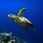
Turtles in Malta
Sea turtles in Malta: hatching, diet, dangers & rescue. From history to conservation, learn how we protect them at Bluewaves Watersports.
L-ahrax tal-Mellieha
L-Ahrax in Mellieħa is a serene natural escape with pine groves, rich history, and stunning views—just minutes from the beautiful Marfa Bay.
All You Need to Know About Malta
Everything you need to know before visiting Malta—travel tips, top sights, beaches, and sea adventures with Bluewaves Watersports.

Malta’s Traditional Food
Maltese food is a rich culinary heritage, from pastizzi to rabbit stew. Explore authentic flavors, recipes, maltese traditions in this ultimate food guide