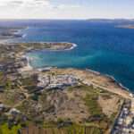
The Grand Harbour of Valletta The Grand Harbour, known as “Il-Port il-Kbir” in Maltese, is a natural harbour located in Valletta, Malta (Google Location). Renowned for its expansive size and strategic significance, it has played a pivotal role throughout Malta’s history, serving as a focal point for military, economic, and cultural developments. Valletta’s Harbour Geographical Layout The harbour’s entrance faces northeast, flanked by Saint Elmo Point to the north and Ricasoli Point to the south, further protected by an isolated breakwater. The Sciberras Peninsula, predominantly occupied by Valletta and its suburb Floriana, forms the northwestern shore and separates the Grand Harbour from the parallel Marsamxett Harbour. The southeastern shore is characterized by a series of inlets and promontories, including Rinella Creek, Kalkara Creek, Dockyard Creek, and French Creek, encompassing the areas of Kalkara and the Three Cities: Cospicua, Vittoriosa, and Senglea. The main waterway extends inland towards Marsa. The Grand Harbour’s Historical Significance The Grand Harbour’s strategic location has rendered it a coveted asset across various eras: Prehistoric and Classical Eras Archaeological findings, such as the Kordin Temples dating back to circa 3700 BC, indicate early human activity along the harbour’s shores. Subsequent Punic and Roman artifacts further attest to the area’s long-standing significance. Medieval Period By the 12th and 13th centuries, the establishment of the Castrum Maris in present-day Birgu underscored the harbour’s defensive importance. Notably, the 1283 Battle of Malta, where Aragonese forces triumphed over a larger Angevin fleet, unfolded at the harbour’s entrance. Knights of St. John Era From 1530 to 1798, the Order of Saint John headquartered in Birgu, fortifying the area extensively, including the transformation of Castrum Maris into Fort Saint Angelo. The harbour was central during the Great Siege of 1565, with the Ottomans’ unsuccessful attempt to seize it marking a turning point in Maltese history. Post-siege, the foundation of Valletta on the Sciberras Peninsula further solidified the harbour’s prominence. British Colonial Period Following the expulsion of the French in 1800, Malta became a British protectorate and was formally declared a colony in 1814 under the Treaty of Paris. The Grand Harbour quickly became a crucial naval base for the Royal Navy, serving as a repair, refueling, and supply station. British investment in fortifications and dockyards reinforced Malta’s role as an imperial stronghold, particularly through the expansion of coastal defenses, including numerous batteries and gun emplacements designed to protect the harbour from naval attacks. These fortifications, such as Fort Rinella with its massive 100-ton gun, played a key role in securing British naval dominance in the Mediterranean. Despite economic and infrastructural advancements, tensions arose over cultural and political issues, leading to demands for self-governance. A constitution granted limited autonomy in 1921, but political instability led to its suspension in 1933. During World War II, Malta’s strategic position made it a prime target for Axis bombing, with the Grand Harbour’s batteries and anti-aircraft defenses playing a crucial role in resisting enemy assaults, though widespread destruction ensued. After the war, Malta’s significance as a British military CONTINUE READING
Category: Malta
Um El Faroud Wreck
The Um El Faroud Wreck Malta is renowned for its stunning dive sites, and one of its most iconic wrecks is the Um El Faroud. Resting off the coast of Wied iż-Żurrieq, this wreck is a must-visit destination for divers seeking an exciting and immersive underwater experience. Once a mighty Libyan oil tanker, the Um El Faroud met a tragic fate before being repurposed as an artificial reef. Today, it attracts thousands of divers annually, offering a unique blend of history, marine life, and exploration. The History of Um El Faroud The Um El Faroud was built in 1969 in England and served as an oil tanker for Libya. Measuring 110 meters in length and 16 meters in width, it was a formidable vessel used for transporting fuel across the Mediterranean. However, its operational days came to an abrupt end in 1995 when a devastating accident occurred during maintenance work at the Malta Drydocks. A gas explosion on board tragically killed nine Maltese workers, leading to the vessel being deemed beyond repair. In honor of the lives lost, a plaque is placed on the wreck as a tribute. After spending three years docked at the Grand Harbour, the Maltese authorities decided to scuttle the ship in 1998 to create an artificial reef. The wreck now lies approximately 36 meters deep, making it accessible to advanced divers looking for an extraordinary dive experience. Diving the Um El Faroud Wreck Location and Conditions The Um El Faroud wreck is located just off the coast of Wied iż-Żurrieq, near the famous Blue Grotto. The wreck sits on a sandy seabed at a depth of 35-36 meters, while the highest point of the ship is at around 18 meters. The waters around the wreck generally offer excellent visibility, ranging from 20 to 40 meters, allowing divers to fully appreciate the grandeur of this sunken giant. Google Map location. Exploring the Wreck Diving the Um El Faroud is an unforgettable experience. The ship is split into two sections due to storm damage in 2005, which adds to its dramatic and haunting beauty. Divers can explore the engine room, cargo holds, bridge, and walkways, all of which are now home to a variety of marine life. For those with appropriate wreck penetration training, there are several safe entry points that allow for an eerie yet fascinating exploration of the ship’s interior. However, the depth and size of the wreck make it best suited for advanced and technical divers. If you want to book a diving trip to explore the Um El Faroud Wreck, contact Dive Vision Malta. Marine Life and Biodiversity Over the years, the Um El Faroud has evolved into a thriving artificial reef, supporting an incredible variety of marine life. Schools of barracuda, amberjack, and bream are often seen circling the wreck, while moray eels and octopuses hide within the crevices. The ship’s surfaces have been colonized by colorful sponges, corals, and algae, creating a vibrant underwater landscape. Divers also frequently encounter groupers, CONTINUE READING
Fomm ir-Rih Beach
Fomm ir-Rih Beach in Malta Along Malta’s secluded western coastline lies Fomm ir-Rih Beach, a hidden gem offering a tranquil retreat for those seeking solace away from the island’s bustling tourist spots. Renowned for its rugged cliffs, clear azure waters, and unspoiled natural beauty, this pebbly beach provides a serene escape into nature’s embrace. A Natural Haven Fomm ir-Rih, translating to “Mouth of the Wind” in Maltese, perfectly encapsulates the essence of this secluded bay. The area is characterized by dramatic limestone cliffs that frame the beach, creating a picturesque landscape that is both awe-inspiring and humbling. The clear, deep blue waters beckon swimmers and snorkelers alike, offering a glimpse into the vibrant marine life thriving beneath the surface. The beach’s isolation has preserved its pristine condition, making it a favorite among those who appreciate nature in its purest form. Getting There Accessing Fomm ir-Rih Beach requires a bit of effort, adding to its secluded charm. The beach is located near the village of Bahria, and reaching it involves a hike through rugged terrain. The path can be steep and uneven, so sturdy footwear is recommended. While the trek may be challenging, the reward is a tranquil beach far removed from the typical tourist trails. It’s advisable to carry ample water and snacks, as there are no facilities available on-site. Activities and Attractions Fomm ir-Rih offers a variety of activities for nature enthusiasts. The clear waters make it an excellent spot for snorkeling and diving, providing opportunities to explore underwater ecosystems teeming with life. Hikers will appreciate the trails that offer panoramic views of the coastline, with the surrounding cliffs and valleys adding to the scenic beauty. The beach’s pebbly shore is ideal for sunbathing and picnicking, allowing visitors to relax and soak in the serene atmosphere. Photographers will find endless inspiration in the dramatic landscapes and the play of light on the water. Best Time to Visit The ideal times to visit Fomm ir-Rih are during the late spring (May to June) and early autumn (September to October). During these shoulder seasons, the weather is pleasant, and the beach is less crowded, enhancing the sense of seclusion. Summer months can be hotter and more crowded, while winter may bring rough seas and cooler temperatures, making swimming less appealing. Preserving the Pristine Environment Visitors to Fomm ir-Rih are encouraged to respect the natural environment to help preserve its unspoiled beauty. This includes taking all litter back when leaving, avoiding disturbance to wildlife, and refraining from removing any natural features. By practicing responsible tourism, we can ensure that this hidden paradise remains intact for future generations to enjoy. Fomm ir-Rih Beach stands as a testament to Malta’s natural beauty, offering a peaceful haven for those willing to venture off the beaten path. Its combination of rugged landscapes, clear waters, and tranquil atmosphere makes it a must-visit destination for travelers seeking an authentic and serene experience. Whether you’re an avid hiker, a snorkeling enthusiast, or simply someone in search of a quiet spot to CONTINUE READING
Wied Musa Battery in Marfa
Wied Musa Battery Perched along the scenic coastline of Marfa Bay in Mellieħa, Malta, the Wied Musa Battery stands as a testament to the island’s rich military history and architectural evolution. Constructed between 1714 and 1716 by the Order of Saint John, this artillery battery was part of a strategic network of coastal defenses designed to safeguard Malta from maritime threats. Over the centuries, the structure has undergone significant transformations, reflecting the island’s changing socio-political landscape. Historical Context and Construction In the early 18th century, the Knights of St. John embarked on an ambitious project to fortify Malta’s coastline against potential invasions. Wied Musa Battery was among the fortifications erected during this period, strategically positioned to oversee the South Comino Channel in tandem with Saint Mary’s Battery on the island of Comino. The battery featured a semi-circular gun platform equipped with a parapet containing four embrasures, allowing for effective artillery deployment. A rectangular blockhouse secured the rear of the platform, providing storage and operational space for the garrison stationed there. Design and Armament The design of Wied Musa Battery was emblematic of the coastal fortifications of its time. The semi-circular gun platform allowed for a broad range of fire, essential for covering expansive maritime approaches. The parapet’s embrasures facilitated the mounting of cannons, and historical records from 1785 indicate that the battery was armed with four 8-pounder guns. A redan—a V-shaped projection—was incorporated into the design to enhance landward defenses, though this feature was later removed during subsequent modifications. Transition to Marfa Palace Hotel The 19th century marked a period of transformation for Wied Musa Battery. As the threat of naval invasions waned, many of Malta’s military structures were repurposed. Wied Musa Battery underwent extensive modifications to be converted into the Marfa Palace Hotel, also known locally as Palazz l-Aħmar (Red Palace). This conversion involved significant alterations, including the incorporation of the original blockhouse into the new hotel structure and the demolition of the redan. Despite these changes, the gun platform remained largely intact, preserving a crucial element of the battery’s original design. Subsequent Uses and Decline Following its tenure as a hotel, the building served various functions, including use as a retreat house and a police station. However, by the 1990s, the structure had fallen into disuse and was eventually abandoned. In 2005, a fire further compromised the building’s integrity, leading to the eviction of squatters who had taken up residence there. Since then, the site has remained unoccupied, with its condition gradually deteriorating over time. Current Condition and Preservation Efforts Today, Wied Musa Battery stands as a poignant reminder of Malta’s layered history. The gun platform, remarkably well-preserved, still showcases original hardstone flagstones and areas designated for stacking cannonballs. The left room of the blockhouse has survived relatively intact, with musketry loopholes offering glimpses into the defensive strategies of the past. Despite its historical significance, the structure remains in a state of neglect, prompting calls for restoration. Estimates suggest that renovation efforts could cost around €1.2 million, with CONTINUE READING
Rdum il-Hmar
Rdum il-Hmar Rdum il-Hmar, also known as Red Cliffs, is a captivating coastal area located near Mellieha in the Northern Region of Malta. This picturesque locale is renowned for its striking red-tinged cliffs, crystal-clear waters, and rich biodiversity, making it a favored destination for nature enthusiasts, hikers, and divers alike. Geographical Features of the cliffs The cliffs of Rdum il-Hmar rise majestically above the Mediterranean Sea, offering panoramic views that are both awe-inspiring and tranquil. The unique reddish hue of the cliffs is due to the iron-rich limestone prevalent in the region, which oxidizes upon exposure to the elements, giving the cliffs their distinctive color. This natural phenomenon not only adds to the visual appeal but also provides a unique geological insight into the island’s formation. The area is characterized by large, split boulders that have created excellent swim-throughs and channels, making it a haven for divers seeking to explore underwater landscapes. The constant action of sea, rain, wind, and temperature variations has sculpted the cliff face over time, resulting in fascinating formations and crevices that are a testament to nature’s enduring artistry. Caves of Rdum il-Hmar Rdum il-Hmar also boasts intriguing caves, including the well-known Smugglers Cave. Located beneath the cliffs on the north side of Marfa Ridge, this shallow cave rests at around 3 meters deep and even features a small swim-through, making it a favorite for divers. The surrounding seabed transitions from sand to rocky terrain, reaching depths of 18 meters. This diverse underwater landscape supports a variety of marine life, offering a unique diving experience. The caves, like the Santa Marija Caves, were carved by the relentless power of the sea, especially during windy days when waves batter the cliffs. These caves provide not only a visual spectacle but also an adventurous exploration site for snorkelers and divers alike. Flora and Fauna The diverse ecosystems around Rdum il-Hmar support a wide array of flora and fauna. The cliffs and surrounding areas are home to various plant species adapted to the Mediterranean climate, including hardy shrubs and endemic flowers that cling to the rocky terrain. Birdwatchers can delight in observing seabirds that nest along the cliffs, taking advantage of the secluded ledges and abundant food supply. Marine life flourishes in the clear waters below, with the rocky seabed providing habitats for numerous fish species, crustaceans, and other marine organisms. Divers often report sightings of octopuses, moray eels, and colorful schools of fish, making each dive a unique experience. Recreational Activities Hiking and Nature Walks The rugged landscape of Rdum il-Hmar offers excellent opportunities for hiking and nature walks. Trails meander along the cliff tops, providing hikers with stunning vistas of the sea and the Maltese coastline. The terrain varies from gentle slopes to more challenging paths, catering to both casual walkers and seasoned hikers. Along the way, one can encounter traditional Maltese flora, historical sites, and perhaps even catch a glimpse of local wildlife. Diving and Snorkeling For those eager to explore beneath the waves, Rdum il-Hmar CONTINUE READING
Slugs Bay in Mellieha
Slugs Bay in Mellieha Tucked away in the northern part of Malta, near the village of Mellieha, Slugs Bay is a hidden treasure. This small, secluded beach offers a peaceful escape from the island’s busier coastlines, inviting visitors to unwind in its untouched, natural beauty. Discovering Slugs Bay Slugs Bay is situated on the south-facing part of the Ahrax Peninsula, one of the arms embracing the one-kilometer-wide Mellieha Bay (Ghadira Bay), Malta’s largest sandy beach. Unlike its larger counterpart, Slugs Bay is a small, secluded inlet, often described as a “postage-stamp sized beach.” This tiny cove is a fascinating result of natural geological processes that have unfolded over time. Massive boulders, once part of the adjacent cliff, broke away and tumbled down, creating a sheltered pocket along the shoreline. Over the years, fine sand carried by the waves gradually settled into this newly formed hollow, transforming it into a small, sandy retreat. The surrounding rocks now act as a natural barrier, shielding the bay from strong currents and winds, helping preserve its calm, clear waters. This unique formation gives Slugs Bay its intimate, untouched charm — a rare, accidental creation of nature’s slow but powerful forces. Accessing the Bay Getting to Slugs Bay is an adventure in itself, adding to the sense of discovery that makes this secluded spot so special. Unlike the more accessible beaches in Malta, Slugs Bay remains hidden from plain sight, there are no clear signs or paths directing visitors to its location. This lack of signage helps preserve its peaceful, off-the-beaten-path charm, ensuring only those willing to venture a little further are rewarded with its beauty. To start the journey, visitors usually park near a small sign on the left side of the road, though this sign doesn’t specifically point to the bay. From there, you’ll need to head towards the sea, where the bay gradually reveals itself from the cliffs above. The first glimpse is breathtaking — the shimmering turquoise water tucked between rugged rocks feels like a secret oasis waiting to be explored. The descent to the bay itself is part of the experience. A narrow, winding path snakes down the cliffside, and while it’s not overly long, it’s certainly uneven and can be steep in places. Sturdy shoes are a must to navigate the rocky terrain safely. Each turn along the path offers a fresh perspective, panoramic views of the sea, the Ahrax Peninsula, and the surrounding cliffs unfold as you make your way down. It’s the kind of path that makes you stop to admire the scenery more than once, soaking in the raw, untouched beauty of Malta’s northern coastline. Though the journey requires a bit of effort, the reward is worth every step. The feeling of finally reaching the soft sand and dipping into the clear, tranquil waters, knowing you’ve arrived somewhere few others do, makes the experience all the more satisfying. or an unforgettable journey, why not arrive by boat? Bluewaves Watersports, based in Marfa Bay, Mellieha, offers fantastic options to CONTINUE READING
Ghajn Hadid Beach
Discovering Ghajn Hadid Beach Ghajn Hadid Beach is a secluded gem nestled along Malta’s northern coastline, offering tranquility and natural beauty for those willing to venture off the beaten path. This lesser-known destination is perfect for adventurous travelers seeking peace, history, and scenic landscapes away from the bustling tourist spots. Getting to Ghajn Hadid Beach Accessible via a scenic 30-minute hike from Mellieha bus station, the journey takes you through quiet roads lined with lush terraced fields, culminating in a steep descent to the rocky shore kissed by turquoise waters. The trail alone is an experience worth having, immersing you in the rugged yet beautiful Maltese landscape. The combination of earthy tones from the fields and the vibrant blues of the sea creates a striking visual contrast that makes the hike feel like a journey into a hidden paradise. A Touch of History The beach is framed by the remnants of the historic Ghajn Hadid Tower, which has stood in ruins since an earthquake in 1856 caused the collapse of its upper floor. This backdrop adds a touch of historical intrigue to the natural splendor of the area. It’s a reminder of Malta’s rich past — a silent witness to centuries gone by. The tower, once part of the island’s coastal defense system, now serves as a rustic landmark that complements the wild beauty of the beach. What to Expect at the Beach Visitors often find themselves alone or in the company of few others, making it an ideal spot for peaceful reflection or a private picnic. The clear, inviting waters are perfect for a refreshing swim, though it’s advisable to wear sturdy footwear due to the rocky terrain and to exercise caution during the steep descent to the beach. Unlike the more popular sandy beaches in Malta, Ghajn Hadid offers a raw, unpolished experience. The shoreline is a mix of smooth rocks and pebbles, making it less comfortable for sunbathing but ideal for those seeking an unspoiled, natural retreat. Hiking and Exploring Nearby Trails For those seeking a bit more adventure, the surrounding area offers additional hiking opportunities. A trek from Ghajn Hadid Beach can lead you to the nearby Imgiebah Beach (also known as Selmun Beach), a beautiful pebble beach that remains largely untouched by tourism. The trail between these beaches provides stunning views of the shoreline, cliffs, and verdant fields, making it a worthwhile excursion for nature enthusiasts. The walk may be challenging at times, but each step rewards you with panoramic views of the Maltese coastline, and if you’re lucky, you might even spot local wildlife like seabirds or lizards basking in the sun. Essential Tips for Visiting It’s important to note that there are no facilities at Ghajn Hadid Beach, so visitors should come prepared with ample water, snacks, and sun protection. The lack of amenities, however, is a small trade-off for the opportunity to experience such unspoiled beauty and serenity. In fact, the absence of commercial development is precisely what makes this beach so CONTINUE READING
St Pauls Islands in Malta
Exploring St Paul’s Islands St Pauls Islands, or Il-Gżejjer ta’ San Pawl in Maltese, are a pair of small, uninhabited islands situated off the coast of Mellieħa, Malta. Steeped in history and surrounded by breathtaking natural beauty, they offer a fascinating day trip for both history buffs and adventure seekers alike. Let’s dive into the islands’ rich past, explore their geographical charm, and discover how you can visit this remarkable spot with Bluewaves Watersports. A Glimpse into History The islands are named after Saint Paul the Apostle, who, according to tradition, was shipwrecked on Malta in 60 A.D. while on his way to Rome. The Book of Acts in the Bible describes how Paul’s ship ran aground on the Maltese coast, and many believe this event occurred near these very islands. It is said that Saint Paul brought Christianity to Malta, making this a significant historical and religious site. A prominent statue of Saint Paul, erected in 1844, stands tall on the larger island, serving as a reminder of this pivotal moment. It’s a stunning sight, especially when viewed from the sea. Over the centuries, the islands have remained largely untouched, preserving their raw, natural beauty. Geographical Marvels St. Paul’s Islands consist of two rugged limestone formations, separated by a narrow channel. The larger island is home to the famous statue, while the smaller one remains a sanctuary for seabirds and marine life. The surrounding waters are crystal clear, making this spot a haven for snorkelers and divers who want to explore the rich underwater world. The islands are located near Mellieħa Bay, offering a picturesque view from the mainland. The coastline is rocky and uneven, but this ruggedness only adds to the islands’ charm. With Mediterranean sunlight dancing on the waves, St. Paul’s Islands make for a breathtaking panorama, especially during sunrise or sunset. Getting to St Pauls Islands Visiting St. Paul’s Islands is an adventure in itself — and there’s no better way to get there than by boat. Bluewaves Watersports, based in Marfa Bay, Mellieħa, offers fantastic options to suit your needs. Rent a Self-Drive Boat: Want to explore at your own pace? Bluewaves Watersports has a large selection of boats, ranging from small, easy-to-handle motorboats to larger vessels ideal for families and groups. All boats are well-maintained, spotlessly clean, and come equipped with all the amenities you need for a comfortable day out — sun canopy, cooler, and safety gear included. Whether you’re after a quick spin or a leisurely cruise around the islands, there’s a boat to match your plans. Private Boat Trip with a Skipper: If you prefer to sit back, relax, and soak in the sights without worrying about navigation, Bluewaves Watersports also offers private boat trips led by experienced skippers. Your skipper will guide you to the best spots around the islands, share local insights, and ensure your trip is smooth and unforgettable. Book Self Drive Boat Book Boat Ride Why Choose Bluewaves Watersports? Located conveniently in Marfa Bay, Mellieħa, Bluewaves Watersports CONTINUE READING
Selmun Palace in Malta
Selmun palace in mellieha – Malta Selmun Palace stands as one of Malta’s most intriguing historical landmarks, an 18th-century masterpiece that reflects the island’s rich heritage and the legacy of the Knights of St. John. Nestled in the serene village of Selmun, close to Mellieħa in the northern part of the island, this grand structure has witnessed centuries of change and remains a symbol of Malta’s past splendor. Origins and Construction Built in the 18th century, Selmun Palace wasn’t designed as a typical noble residence or a fortification. Instead, it served a rather unique purpose, as a hunting lodge and retreat for the Knights of St. John, who ruled Malta at the time. The palace was funded by the Monte della Redenzione degli Schiavi, an initiative set up to collect funds to rescue Christian slaves from Ottoman captivity. The architecture of the palace is reminiscent of a castle, with a stately, square structure and corner towers giving it a fortress-like appearance. Its design is attributed to architect Domenico Cachia, who drew inspiration from Verdala Palace, another notable Knights’ retreat. The building’s imposing façade, large balconies, and surrounding open landscape provided the perfect setting for leisurely pursuits, including hunting — a favored pastime of the Knights. Historical Significance Beyond its role as a hunting lodge, the palace became a place of refuge and relaxation for the knights. It symbolized the wealth and power of the Order, standing as a testament to their ability to build opulent estates despite the island’s limited resources. During the 19th and 20th centuries, the palace’s function evolved. It was eventually repurposed as a hotel in the mid-20th century, drawing visitors seeking a luxurious, historical stay with breathtaking views of the Mediterranean and the surrounding countryside. Though the hotel eventually closed, the palace remains an iconic structure. Selmun Palace also holds significance due to its strategic location. Overlooking Mellieħa Bay (Ghadira) and facing St. Paul’s Islands, it provided a vantage point that could have been used for early warning during naval incursions, although it was never built with defense as a primary function. Architectural Features The palace’s exterior showcases a Baroque style, characterized by symmetrical design and ornamental details. The massive, rectangular structure boasts four corner towers that rise slightly above the main building, giving it a fortress-like silhouette. Inside, the palace was known for its spacious rooms, high ceilings, and large windows — designed to let in ample light and offer panoramic views of the surrounding landscape. While the interior has since fallen into disrepair, glimpses of its past grandeur remain, from remnants of intricate plasterwork to grand stone staircases. The palace was surrounded by extensive grounds, including gardens and open fields used for hunting expeditions. Today, the area retains a wild, natural charm, making it a favorite spot for hikers and those seeking a peaceful retreat. The Modern State of Selmun Palace Although the palace is currently closed to the public, its exterior remains a captivating sight for anyone exploring the Selmun area. There have been CONTINUE READING
Imgiebah Beach in Malta
Imghiebah Beach in Malta Imgiebah Beach in the North of Malta is a hidden gem that offers a tranquil escape from the island’s busier tourist spots. This secluded bay, known for its unspoiled beauty, combines natural charm with a sense of peaceful isolation, making it a perfect spot for nature lovers and adventurers alike. Geographical Overview Imgiebah Beach is situated near Selmun, within the limits of Mellieha, a picturesque village in the northern region of Malta. The beach itself is a small, sandy cove flanked by rocky outcrops and lush greenery. Unlike many of Malta’s more commercial beaches, Imgiebah retains a wild, untouched feel, thanks in part to its remote location and the challenging terrain surrounding it. The area is characterized by rugged limestone cliffs, Mediterranean scrub, and rolling hills. The crystal-clear waters of the bay are shallow near the shore, gradually deepening into a vibrant blue further out. This makes it an excellent spot for snorkeling, with an underwater landscape teeming with marine life. Historical Context The region around Imgiebah has a rich historical background. Selmun is known for its 18th-century Selmun Palace, a grand hunting lodge built by the Knights of St. John. The palace, which overlooks the bay, was once used as a retreat for the knights and later as a hotel. Although the palace is currently closed to the public, it remains an iconic landmark that adds to the area’s historical allure. Additionally, Mellieha itself has a deep-rooted history, with evidence of human settlement dating back to the Bronze Age. The area played a strategic role during various periods of Maltese history, from the time of the Phoenicians and Romans to the more recent World War II era, where nearby shelters were carved into the rock. Nature and Wildlife The surrounding landscape of The beach is part of a Natura 2000 site, a network of protected areas across Europe aimed at conserving valuable habitats and species. The area is home to diverse flora and fauna, including endemic plants like the Maltese salt tree and various types of wild thyme. Birdwatchers may also spot species such as the Sardinian warbler and blue rock thrush, Malta’s national bird. The beach’s untouched nature means that it lacks the amenities of more popular beaches, but that’s precisely its charm. Visitors can enjoy a truly immersive experience in nature, away from the crowds and noise. How to Reach Imghiebah Beach Getting to Imgiebah Beach requires a bit of determination, but the reward is well worth the effort. The beach is accessible by car or on foot, but the final stretch involves a somewhat rough, off-road path. If driving, head towards Mellieha and follow signs to Selmun. After passing Selmun Palace, continue along the narrow road that leads down towards the bay. The last part of the route is unpaved and can be challenging for smaller cars, so many visitors choose to park along the road and walk the remaining distance. The descent to the beach takes around 10 to 15 minutes on foot. For those CONTINUE READING