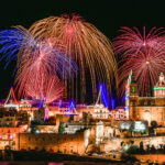
The Vibrant Feasts of Malta: A Celebration of Faith, Tradition, and Culture Malta, a small island nation in the heart of the Mediterranean, is known for its rich history, stunning landscapes, and warm, welcoming people. However, one of the most captivating aspects of Maltese culture is the island’s deep-rooted tradition of religious feasts. These lively celebrations, which take place throughout the year, are a blend of spirituality, community, and festivity, drawing locals and tourists alike to experience the unique atmosphere of Malta’s vibrant villages. Feasts, or “festas,” are an integral part of Maltese life. While they are primarily religious in nature, honoring patron saints and their respective churches, they also serve as important social events, offering a sense of unity, joy, and pride. Visitors to Malta can expect to see colorful processions, hear bands playing traditional marches, and witness spectacular fireworks displays — all while enjoying local food and drinks in a festive atmosphere. The History of Maltese Feasts The tradition of feasts in Malta dates back centuries, influenced by the island’s deep Catholic roots and its long history of occupation by various powers, including the Phoenicians, Romans, Arabs, Normans, and the Order of St. John (the Knights Hospitaller). Under the Knights, Malta became a center of Christian devotion and military might, and religious observances were a central part of daily life. This influence still shapes the way feasts are celebrated today. The feasts are usually dedicated to the patron saints of towns and villages across Malta. It is common for every town or village to have its own annual feast, often held on the feast day of its patron saint. The festivities typically start on the Saturday before the actual feast day and continue through to Sunday, sometimes even lasting for a whole week. During this time, the local church is adorned with colorful decorations, and the streets are filled with lights, banners, and flowers. What to Expect at a Maltese Feast A Maltese feast is a multi-sensory experience that combines religious observance with lively festivities. Here are some of the key elements that you can expect when attending one of these vibrant events: The Procession: The heart of any feast is the procession, which is typically held on the feast day itself. A statue or image of the patron saint is paraded through the streets, often accompanied by prayers, hymns, and incense. The procession is a deeply religious event, with many locals participating by walking alongside the statue, carrying candles or offering prayers. The procession is often accompanied by a band, playing traditional marches, which add to the festive atmosphere. Fireworks Displays: One of the most spectacular aspects of Maltese feasts is the fireworks. These displays are often grand and impressive, lighting up the night sky in vibrant colors. The fireworks are traditionally fired from the church or a nearby open space, and each village competes with others to put on the best display. The history of fireworks in Malta dates back to the 18th century, and they CONTINUE READING
Category: Malta

Sharks in Malta
Sharks in Malta: A Rare and Beautiful Encounter with Nature At Bluewaves Watersports, we’re passionate about Malta’s stunning marine life. Our crystal-clear Mediterranean waters are home to an incredible array of sea creatures, from playful dolphins to colorful fish. One fascinating but often misunderstood ocean dweller very rarely makes an appearance in our waters. The shark. Before your imagination runs wild, let us reassure you, Malta is not known for shark activity, especially near the coast. In fact, shark sightings here are very rare. But when one does appear, as happened recently in Sliema, it’s a wonderful reminder of how rich and healthy our marine ecosystem truly is. A Peaceful Visitor in Sliema – 09/05/2025 On May 9th, 2025, beachgoers and walkers along the Sliema coast witnessed a special and rare sight, a small shark was seen calmly swimming close to shore. The video quickly made rounds on social media, with onlookers expressing surprise and awe at the peaceful presence of this ocean visitor. Marine experts believe the shark was likely a blue shark (Prionace glauca), a sleek, deep-sea species known for its striking blue coloration and gentle nature. These sharks live far offshore and are not typically found near beaches. Sightings near the coast are exceptionally rare, and this one came with calm seas and perfect visibility, ideal conditions for such an encounter. The shark posed no threat to swimmers, and officials confirmed there was no danger or need for alarm. In fact, it was a positive sign that our local waters remain clean and biodiverse. Sharks are essential indicators of a healthy ocean, and seeing one in Malta is a rare and special moment to appreciate. Sharks in Malta: The Facts Malta’s surrounding waters are home to over 30 species of sharks, but most are small, non-aggressive, and live in deep waters far from shore. The reality is that you are extremely unlikely to ever see a shark while swimming, snorkeling, or enjoying water activities here. In fact, shark-related incidents in Malta are virtually unheard of. Sharks do not hunt humans, their diet consists mainly of fish and squid, and they are naturally wary of people. Interestingly, the waters near Filfla, an uninhabited islet south of Malta, are one of the island’s richest marine ecosystems and an occasional habitat for larger marine species, including some types of sharks. However, this area is far from regular swimming zones and is a protected nature reserve, ensuring minimal interaction with humans. At Bluewaves Watersports, safety is our top priority. In all our years operating here at Bluewaves Watersports, we’ve never had any kind of shark-related issue. The sighting on 09/05/2025 in Sliema was not a warning, it was a rare and beautiful reminder of nature’s balance. Sharks: Guardians of the Sea Sharks are a vital part of the marine ecosystem. As apex predators, they help maintain the balance of other marine life, keeping populations in check and supporting the overall health of coral reefs and fish stocks. Despite their important role in CONTINUE READING

Maltese Traditional Buses
The Charm and Legacy of Maltese Traditional Buses When one thinks of Malta, images of crystal-clear waters, ancient architecture, and sun-soaked landscapes might come to mind. But for decades, something else colorful and unmistakably unique captured the heart of this Mediterranean island — the iconic Maltese traditional bus. These buses weren’t just a means of transportation; they were moving symbols of Maltese culture, hand-decorated masterpieces, and beloved relics of a bygone era. A BUS History The story of Maltese traditional buses dates back to the early 20th century. The very first buses appeared on the island in 1905, and over time, they became the primary method of public transportation. By the 1920s and 30s, most buses were imported as bare chassis from manufacturers like Bedford, Leyland, and AEC. These chassis were then transformed into unique vehicles by local craftsmen who built the bodywork and designed the interiors. What made these buses so special was that no two were exactly the same. Each one was personalized by its driver, who was often also the owner. This resulted in a fleet that was as diverse in appearance as it was functional — buses were often painted in vibrant colors, decorated with religious symbols, witty sayings, family crests, and even chrome ornaments. From bold reds and canary yellows to lime greens and sky blues, each bus was a rolling canvas. Cultural Icons on Wheels More than just transportation, Maltese buses became an integral part of the island’s culture and identity. The drivers took immense pride in their vehicles, maintaining them meticulously and often investing significant time and money into decoration and repair. Riding one of these buses was not merely a commute; it was an experience. Tourists and locals alike grew fond of the unique ambiance: the scent of engine oil and leather seats, the buzz of conversation, and the occasional blast of Maltese or Italian music from the driver’s radio. The interiors often included religious icons, photos of loved ones, and even little shrines tucked into dashboards. For decades, these buses connected rural villages to urban centers and became a part of daily life in Malta. The Farewell: Modernization and Controversy By the early 2000s, however, Malta’s aging bus fleet began to draw criticism. The vehicles, while charming, were becoming outdated. Many lacked air conditioning, were prone to breakdowns, and didn’t meet modern accessibility standards. Pollution was also a growing concern, with the diesel engines contributing heavily to urban smog. In 2011, Malta undertook a major overhaul of its public transport system. The traditional buses were replaced with a standardized, modern fleet operated initially by Arriva and later by other private operators. Though more efficient and environmentally friendly, the new buses didn’t carry the same charm — and their arrival sparked a wave of nostalgia, sadness, and even protest among locals and vintage bus enthusiasts. Preserving the Bus Legacy Thankfully, all was not lost. Recognizing their cultural significance, efforts were made to preserve many of the traditional buses. Today, several restored buses CONTINUE READING
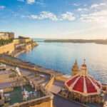
Grand Harbour of Malta in Valletta
The Grand Harbour of Valletta The Grand Harbour, known as “Il-Port il-Kbir” in Maltese, is a natural harbour located in Valletta, Malta (Google Location). Renowned for its expansive size and strategic significance, it has played a pivotal role throughout Malta’s history, serving as a focal point for military, economic, and cultural developments. Valletta’s Harbour Geographical Layout The harbour’s entrance faces northeast, flanked by Saint Elmo Point to the north and Ricasoli Point to the south, further protected by an isolated breakwater. The Sciberras Peninsula, predominantly occupied by Valletta and its suburb Floriana, forms the northwestern shore and separates the Grand Harbour from the parallel Marsamxett Harbour. The southeastern shore is characterized by a series of inlets and promontories, including Rinella Creek, Kalkara Creek, Dockyard Creek, and French Creek, encompassing the areas of Kalkara and the Three Cities: Cospicua, Vittoriosa, and Senglea. The main waterway extends inland towards Marsa. The Grand Harbour’s Historical Significance The Grand Harbour’s strategic location has rendered it a coveted asset across various eras: Prehistoric and Classical Eras Archaeological findings, such as the Kordin Temples dating back to circa 3700 BC, indicate early human activity along the harbour’s shores. Subsequent Punic and Roman artifacts further attest to the area’s long-standing significance. Medieval Period By the 12th and 13th centuries, the establishment of the Castrum Maris in present-day Birgu underscored the harbour’s defensive importance. Notably, the 1283 Battle of Malta, where Aragonese forces triumphed over a larger Angevin fleet, unfolded at the harbour’s entrance. Knights of St. John Era From 1530 to 1798, the Order of Saint John headquartered in Birgu, fortifying the area extensively, including the transformation of Castrum Maris into Fort Saint Angelo. The harbour was central during the Great Siege of 1565, with the Ottomans’ unsuccessful attempt to seize it marking a turning point in Maltese history. Post-siege, the foundation of Valletta on the Sciberras Peninsula further solidified the harbour’s prominence. British Colonial Period Following the expulsion of the French in 1800, Malta became a British protectorate and was formally declared a colony in 1814 under the Treaty of Paris. The Grand Harbour quickly became a crucial naval base for the Royal Navy, serving as a repair, refueling, and supply station. British investment in fortifications and dockyards reinforced Malta’s role as an imperial stronghold, particularly through the expansion of coastal defenses, including numerous batteries and gun emplacements designed to protect the harbour from naval attacks. These fortifications, such as Fort Rinella with its massive 100-ton gun, played a key role in securing British naval dominance in the Mediterranean. Despite economic and infrastructural advancements, tensions arose over cultural and political issues, leading to demands for self-governance. A constitution granted limited autonomy in 1921, but political instability led to its suspension in 1933. During World War II, Malta’s strategic position made it a prime target for Axis bombing, with the Grand Harbour’s batteries and anti-aircraft defenses playing a crucial role in resisting enemy assaults, though widespread destruction ensued. After the war, Malta’s significance as a British military CONTINUE READING

Um El Faroud Wreck
The Um El Faroud Wreck Malta is renowned for its stunning dive sites, and one of its most iconic wrecks is the Um El Faroud. Resting off the coast of Wied iż-Żurrieq, this wreck is a must-visit destination for divers seeking an exciting and immersive underwater experience. Once a mighty Libyan oil tanker, the Um El Faroud met a tragic fate before being repurposed as an artificial reef. Today, it attracts thousands of divers annually, offering a unique blend of history, marine life, and exploration. The History of Um El Faroud The Um El Faroud was built in 1969 in England and served as an oil tanker for Libya. Measuring 110 meters in length and 16 meters in width, it was a formidable vessel used for transporting fuel across the Mediterranean. However, its operational days came to an abrupt end in 1995 when a devastating accident occurred during maintenance work at the Malta Drydocks. A gas explosion on board tragically killed nine Maltese workers, leading to the vessel being deemed beyond repair. In honor of the lives lost, a plaque is placed on the wreck as a tribute. After spending three years docked at the Grand Harbour, the Maltese authorities decided to scuttle the ship in 1998 to create an artificial reef. The wreck now lies approximately 36 meters deep, making it accessible to advanced divers looking for an extraordinary dive experience. Diving the Um El Faroud Wreck Location and Conditions The Um El Faroud wreck is located just off the coast of Wied iż-Żurrieq, near the famous Blue Grotto. The wreck sits on a sandy seabed at a depth of 35-36 meters, while the highest point of the ship is at around 18 meters. The waters around the wreck generally offer excellent visibility, ranging from 20 to 40 meters, allowing divers to fully appreciate the grandeur of this sunken giant. Google Map location. Exploring the Wreck Diving the Um El Faroud is an unforgettable experience. The ship is split into two sections due to storm damage in 2005, which adds to its dramatic and haunting beauty. Divers can explore the engine room, cargo holds, bridge, and walkways, all of which are now home to a variety of marine life. For those with appropriate wreck penetration training, there are several safe entry points that allow for an eerie yet fascinating exploration of the ship’s interior. However, the depth and size of the wreck make it best suited for advanced and technical divers. If you want to book a diving trip to explore the Um El Faroud Wreck, contact Dive Vision Malta. Marine Life and Biodiversity Over the years, the Um El Faroud has evolved into a thriving artificial reef, supporting an incredible variety of marine life. Schools of barracuda, amberjack, and bream are often seen circling the wreck, while moray eels and octopuses hide within the crevices. The ship’s surfaces have been colonized by colorful sponges, corals, and algae, creating a vibrant underwater landscape. Divers also frequently encounter groupers, CONTINUE READING

Fomm ir-Rih Beach
Fomm ir-Rih Beach in Malta Along Malta’s secluded western coastline lies Fomm ir-Rih Beach, a hidden gem offering a tranquil retreat for those seeking solace away from the island’s bustling tourist spots. Renowned for its rugged cliffs, clear azure waters, and unspoiled natural beauty, this pebbly beach provides a serene escape into nature’s embrace. A Natural Haven Fomm ir-Rih, translating to “Mouth of the Wind” in Maltese, perfectly encapsulates the essence of this secluded bay. The area is characterized by dramatic limestone cliffs that frame the beach, creating a picturesque landscape that is both awe-inspiring and humbling. The clear, deep blue waters beckon swimmers and snorkelers alike, offering a glimpse into the vibrant marine life thriving beneath the surface. The beach’s isolation has preserved its pristine condition, making it a favorite among those who appreciate nature in its purest form. Getting There Accessing Fomm ir-Rih Beach requires a bit of effort, adding to its secluded charm. The beach is located near the village of Bahria, and reaching it involves a hike through rugged terrain. The path can be steep and uneven, so sturdy footwear is recommended. While the trek may be challenging, the reward is a tranquil beach far removed from the typical tourist trails. It’s advisable to carry ample water and snacks, as there are no facilities available on-site. Activities and Attractions Fomm ir-Rih offers a variety of activities for nature enthusiasts. The clear waters make it an excellent spot for snorkeling and diving, providing opportunities to explore underwater ecosystems teeming with life. Hikers will appreciate the trails that offer panoramic views of the coastline, with the surrounding cliffs and valleys adding to the scenic beauty. The beach’s pebbly shore is ideal for sunbathing and picnicking, allowing visitors to relax and soak in the serene atmosphere. Photographers will find endless inspiration in the dramatic landscapes and the play of light on the water. Best Time to Visit The ideal times to visit Fomm ir-Rih are during the late spring (May to June) and early autumn (September to October). During these shoulder seasons, the weather is pleasant, and the beach is less crowded, enhancing the sense of seclusion. Summer months can be hotter and more crowded, while winter may bring rough seas and cooler temperatures, making swimming less appealing. Preserving the Pristine Environment Visitors to Fomm ir-Rih are encouraged to respect the natural environment to help preserve its unspoiled beauty. This includes taking all litter back when leaving, avoiding disturbance to wildlife, and refraining from removing any natural features. By practicing responsible tourism, we can ensure that this hidden paradise remains intact for future generations to enjoy. Fomm ir-Rih Beach stands as a testament to Malta’s natural beauty, offering a peaceful haven for those willing to venture off the beaten path. Its combination of rugged landscapes, clear waters, and tranquil atmosphere makes it a must-visit destination for travelers seeking an authentic and serene experience. Whether you’re an avid hiker, a snorkeling enthusiast, or simply someone in search of a quiet spot to CONTINUE READING

Wied Musa Battery in Marfa
Wied Musa Battery Perched along the scenic coastline of Marfa Bay in Mellieħa, Malta, the Wied Musa Battery stands as a testament to the island’s rich military history and architectural evolution. Constructed between 1714 and 1716 by the Order of Saint John, this artillery battery was part of a strategic network of coastal defenses designed to safeguard Malta from maritime threats. Over the centuries, the structure has undergone significant transformations, reflecting the island’s changing socio-political landscape. Historical Context and Construction In the early 18th century, the Knights of St. John embarked on an ambitious project to fortify Malta’s coastline against potential invasions. Wied Musa Battery was among the fortifications erected during this period, strategically positioned to oversee the South Comino Channel in tandem with Saint Mary’s Battery on the island of Comino. The battery featured a semi-circular gun platform equipped with a parapet containing four embrasures, allowing for effective artillery deployment. A rectangular blockhouse secured the rear of the platform, providing storage and operational space for the garrison stationed there. Design and Armament The design of Wied Musa Battery was emblematic of the coastal fortifications of its time. The semi-circular gun platform allowed for a broad range of fire, essential for covering expansive maritime approaches. The parapet’s embrasures facilitated the mounting of cannons, and historical records from 1785 indicate that the battery was armed with four 8-pounder guns. A redan—a V-shaped projection—was incorporated into the design to enhance landward defenses, though this feature was later removed during subsequent modifications. Transition to Marfa Palace Hotel The 19th century marked a period of transformation for Wied Musa Battery. As the threat of naval invasions waned, many of Malta’s military structures were repurposed. Wied Musa Battery underwent extensive modifications to be converted into the Marfa Palace Hotel, also known locally as Palazz l-Aħmar (Red Palace). This conversion involved significant alterations, including the incorporation of the original blockhouse into the new hotel structure and the demolition of the redan. Despite these changes, the gun platform remained largely intact, preserving a crucial element of the battery’s original design. Subsequent Uses and Decline Following its tenure as a hotel, the building served various functions, including use as a retreat house and a police station. However, by the 1990s, the structure had fallen into disuse and was eventually abandoned. In 2005, a fire further compromised the building’s integrity, leading to the eviction of squatters who had taken up residence there. Since then, the site has remained unoccupied, with its condition gradually deteriorating over time. Current Condition and Preservation Efforts Today, Wied Musa Battery stands as a poignant reminder of Malta’s layered history. The gun platform, remarkably well-preserved, still showcases original hardstone flagstones and areas designated for stacking cannonballs. The left room of the blockhouse has survived relatively intact, with musketry loopholes offering glimpses into the defensive strategies of the past. Despite its historical significance, the structure remains in a state of neglect, prompting calls for restoration. Estimates suggest that renovation efforts could cost around €1.2 million, with CONTINUE READING

Rdum il-Hmar
Rdum il-Hmar Rdum il-Hmar, also known as Red Cliffs, is a captivating coastal area located near Mellieha in the Northern Region of Malta. This picturesque locale is renowned for its striking red-tinged cliffs, crystal-clear waters, and rich biodiversity, making it a favored destination for nature enthusiasts, hikers, and divers alike. Geographical Features of the cliffs The cliffs of Rdum il-Hmar rise majestically above the Mediterranean Sea, offering panoramic views that are both awe-inspiring and tranquil. The unique reddish hue of the cliffs is due to the iron-rich limestone prevalent in the region, which oxidizes upon exposure to the elements, giving the cliffs their distinctive color. This natural phenomenon not only adds to the visual appeal but also provides a unique geological insight into the island’s formation. The area is characterized by large, split boulders that have created excellent swim-throughs and channels, making it a haven for divers seeking to explore underwater landscapes. The constant action of sea, rain, wind, and temperature variations has sculpted the cliff face over time, resulting in fascinating formations and crevices that are a testament to nature’s enduring artistry. Caves of Rdum il-Hmar Rdum il-Hmar also boasts intriguing caves, including the well-known Smugglers Cave. Located beneath the cliffs on the north side of Marfa Ridge, this shallow cave rests at around 3 meters deep and even features a small swim-through, making it a favorite for divers. The surrounding seabed transitions from sand to rocky terrain, reaching depths of 18 meters. This diverse underwater landscape supports a variety of marine life, offering a unique diving experience. The caves, like the Santa Marija Caves, were carved by the relentless power of the sea, especially during windy days when waves batter the cliffs. These caves provide not only a visual spectacle but also an adventurous exploration site for snorkelers and divers alike. Flora and Fauna The diverse ecosystems around Rdum il-Hmar support a wide array of flora and fauna. The cliffs and surrounding areas are home to various plant species adapted to the Mediterranean climate, including hardy shrubs and endemic flowers that cling to the rocky terrain. Birdwatchers can delight in observing seabirds that nest along the cliffs, taking advantage of the secluded ledges and abundant food supply. Marine life flourishes in the clear waters below, with the rocky seabed providing habitats for numerous fish species, crustaceans, and other marine organisms. Divers often report sightings of octopuses, moray eels, and colorful schools of fish, making each dive a unique experience. Recreational Activities Hiking and Nature Walks The rugged landscape of Rdum il-Hmar offers excellent opportunities for hiking and nature walks. Trails meander along the cliff tops, providing hikers with stunning vistas of the sea and the Maltese coastline. The terrain varies from gentle slopes to more challenging paths, catering to both casual walkers and seasoned hikers. Along the way, one can encounter traditional Maltese flora, historical sites, and perhaps even catch a glimpse of local wildlife. Diving and Snorkeling For those eager to explore beneath the waves, Rdum il-Hmar CONTINUE READING

Slugs Bay in Mellieha
Slugs Bay in Mellieha Tucked away in the northern part of Malta, near the village of Mellieha, Slugs Bay is a hidden treasure. This small, secluded beach offers a peaceful escape from the island’s busier coastlines, inviting visitors to unwind in its untouched, natural beauty. Discovering Slugs Bay Slugs Bay is situated on the south-facing part of the Ahrax Peninsula, one of the arms embracing the one-kilometer-wide Mellieha Bay (Ghadira Bay), Malta’s largest sandy beach. Unlike its larger counterpart, Slugs Bay is a small, secluded inlet, often described as a “postage-stamp sized beach.” This tiny cove is a fascinating result of natural geological processes that have unfolded over time. Massive boulders, once part of the adjacent cliff, broke away and tumbled down, creating a sheltered pocket along the shoreline. Over the years, fine sand carried by the waves gradually settled into this newly formed hollow, transforming it into a small, sandy retreat. The surrounding rocks now act as a natural barrier, shielding the bay from strong currents and winds, helping preserve its calm, clear waters. This unique formation gives Slugs Bay its intimate, untouched charm — a rare, accidental creation of nature’s slow but powerful forces. Accessing the Bay Getting to Slugs Bay is an adventure in itself, adding to the sense of discovery that makes this secluded spot so special. Unlike the more accessible beaches in Malta, Slugs Bay remains hidden from plain sight, there are no clear signs or paths directing visitors to its location. This lack of signage helps preserve its peaceful, off-the-beaten-path charm, ensuring only those willing to venture a little further are rewarded with its beauty. To start the journey, visitors usually park near a small sign on the left side of the road, though this sign doesn’t specifically point to the bay. From there, you’ll need to head towards the sea, where the bay gradually reveals itself from the cliffs above. The first glimpse is breathtaking — the shimmering turquoise water tucked between rugged rocks feels like a secret oasis waiting to be explored. The descent to the bay itself is part of the experience. A narrow, winding path snakes down the cliffside, and while it’s not overly long, it’s certainly uneven and can be steep in places. Sturdy shoes are a must to navigate the rocky terrain safely. Each turn along the path offers a fresh perspective, panoramic views of the sea, the Ahrax Peninsula, and the surrounding cliffs unfold as you make your way down. It’s the kind of path that makes you stop to admire the scenery more than once, soaking in the raw, untouched beauty of Malta’s northern coastline. Though the journey requires a bit of effort, the reward is worth every step. The feeling of finally reaching the soft sand and dipping into the clear, tranquil waters, knowing you’ve arrived somewhere few others do, makes the experience all the more satisfying. or an unforgettable journey, why not arrive by boat? Bluewaves Watersports, based in Marfa Bay, Mellieha, offers fantastic options to CONTINUE READING

Ghajn Hadid Beach
Discovering Ghajn Hadid Beach Ghajn Hadid Beach is a secluded gem nestled along Malta’s northern coastline, offering tranquility and natural beauty for those willing to venture off the beaten path. This lesser-known destination is perfect for adventurous travelers seeking peace, history, and scenic landscapes away from the bustling tourist spots. Getting to Ghajn Hadid Beach Accessible via a scenic 30-minute hike from Mellieha bus station, the journey takes you through quiet roads lined with lush terraced fields, culminating in a steep descent to the rocky shore kissed by turquoise waters. The trail alone is an experience worth having, immersing you in the rugged yet beautiful Maltese landscape. The combination of earthy tones from the fields and the vibrant blues of the sea creates a striking visual contrast that makes the hike feel like a journey into a hidden paradise. A Touch of History The beach is framed by the remnants of the historic Ghajn Hadid Tower, which has stood in ruins since an earthquake in 1856 caused the collapse of its upper floor. This backdrop adds a touch of historical intrigue to the natural splendor of the area. It’s a reminder of Malta’s rich past — a silent witness to centuries gone by. The tower, once part of the island’s coastal defense system, now serves as a rustic landmark that complements the wild beauty of the beach. What to Expect at the Beach Visitors often find themselves alone or in the company of few others, making it an ideal spot for peaceful reflection or a private picnic. The clear, inviting waters are perfect for a refreshing swim, though it’s advisable to wear sturdy footwear due to the rocky terrain and to exercise caution during the steep descent to the beach. Unlike the more popular sandy beaches in Malta, Ghajn Hadid offers a raw, unpolished experience. The shoreline is a mix of smooth rocks and pebbles, making it less comfortable for sunbathing but ideal for those seeking an unspoiled, natural retreat. Hiking and Exploring Nearby Trails For those seeking a bit more adventure, the surrounding area offers additional hiking opportunities. A trek from Ghajn Hadid Beach can lead you to the nearby Imgiebah Beach (also known as Selmun Beach), a beautiful pebble beach that remains largely untouched by tourism. The trail between these beaches provides stunning views of the shoreline, cliffs, and verdant fields, making it a worthwhile excursion for nature enthusiasts. The walk may be challenging at times, but each step rewards you with panoramic views of the Maltese coastline, and if you’re lucky, you might even spot local wildlife like seabirds or lizards basking in the sun. Essential Tips for Visiting It’s important to note that there are no facilities at Ghajn Hadid Beach, so visitors should come prepared with ample water, snacks, and sun protection. The lack of amenities, however, is a small trade-off for the opportunity to experience such unspoiled beauty and serenity. In fact, the absence of commercial development is precisely what makes this beach so CONTINUE READING